Places
Cabo de Gata Villages: Agua Amarga, San José, Las Negras and More
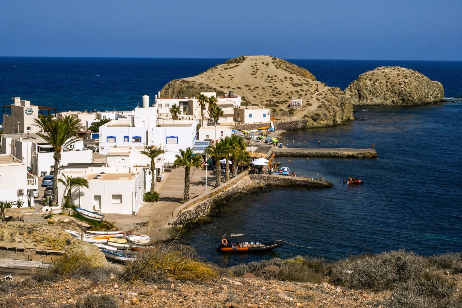
Cabo de Gata has no main town. The park is dotted with small white villages, most of them on the coast and most of them in the municipality of Níjar, and each has a different character. Agua Amarga is the quiet, rather polished fishing village of the north-east; San José is the liveliest and best served, and the gateway to Genoveses and Mónsul; La Isleta del Moro is a tiny fishing harbour; Rodalquilar is an old gold-mining village in a volcanic valley; Las Negras is the laid-back starting point for Cala San Pedro; and Níjar town, inland, is where the crafts come from.
In short: first-timers and anyone without a car should stay in San José; couples after quiet should look at Agua Amarga or La Isleta; walkers and anyone curious about the park’s history will like Rodalquilar; and Las Negras suits a relaxed, outdoors crowd. This guide compares them one by one, from south-west to north-east, and ends with Níjar town.
How the villages fit together
Níjar is the largest municipality in Almería province by area, and its tourism office counts 25 settlements within it. Most of the park’s villages belong to it; the rest of the park lies in the municipalities of Almería and Carboneras. That is why so much practical information, from trails to accommodation, comes from Níjar’s tourism office.
The villages are small, and none of them is a resort town in the way that Mojácar, just outside the park to the north, is. There is no single centre, so where you stay shapes your trip: see our guide to getting to Cabo de Gata for the roads, the buses and the beach access rules.
San José
What it is like
San José is a fishing village surrounded by the Sierra de Gata, 56 km from Almería, set between the Cerro de Enmedio and Cala Higuera. Its very white houses are stepped up the hills that enclose the bay and the village beach. Níjar’s tourism office calls it one of the most sought-after destinations in the area, because it has a bit of everything: services, beaches, wild coves and sport.
The bay itself has a fine sandy beach more than a kilometre long, with the marina at one end linked to the Plaza de Génova by a seafront promenade that has a market every afternoon.
What is nearby
San José is the base for the park’s most famous beaches, which lie to its west along an unsurfaced track:
- Genoveses is no more than a kilometre from San José, and the track is easy, even with a pushchair.
- Mónsul is reached by a 4-kilometre forest track from San José.
- In summer, motor-vehicle access to these beaches is regulated: vehicles pay a single €6 fee, and the barrier closes at set hours or early when the car parks are full. A shuttle bus from San José drops you at the beach access points, and walking or cycling is free.
From the village, a guided e-bike tour of about 4 hours rides along dirt tracks to Mónsul beach, the Vela Blanca viewpoint and Genoveses beach, with time for a swim. Our guide to the beaches covers Genoveses and Mónsul in detail.
Getting there without a car
San José is the easiest village to reach by bus. Buses leave Almería for San José at 10:00, 13:15 and 18:30 Monday to Saturday, and at 10:00 and 18:30 on Sundays and holidays; the fare is €3.10.
Who it suits
First-time visitors, families, and anyone without a car. Expect it to be busy in July and August.
Los Escullos
Between San José and La Isleta, Los Escullos is barely a village at all: a tiny cluster of white houses and, beyond them, the eighteenth-century Castillo de San Felipe. Around the castle is a fossil dune worn into strange shapes, and the Arco and Esparto beaches are right here.
The dune is fragile: climbing its rock outcrops is prohibited. Los Escullos is also home to one of the park’s campsites, covered in our guide to camping in Cabo de Gata.
La Isleta del Moro
What it is like
La Isleta del Moro is a natural anchorage that its inhabitants still use, and its fishing tradition is alive at every step. It is a small harbour village of white houses around that anchorage. Níjar’s tourism office puts it simply: you cannot leave without eating its fresh fish on a terrace facing the view.
The village is named after the small islet off its coast, where the most famous of the pirates who raided this shore, Mohamed Arraez, is said to have hidden.
What is nearby
- Beaches. The nicest beaches near La Isleta are Playa del Peñón Blanco and Cala de los Toros.
- A viewpoint. On the road towards Rodalquilar, past the turning for Cala de los Toros, the Mirador de la Amatista looks out over the coast from high above.
- Diving. Níjar’s tourism directory lists diving businesses in the village, and the rocky coast here is good for snorkelling on calm days.
Who it suits
Couples, food lovers, snorkellers and divers, and anyone who wants a quiet night more than a choice of bars.
Rodalquilar
What it is like
Rodalquilar sits a little inland, in a valley that is the caldera of an old volcano. It was a prosperous mining settlement while its land held gold, then a ghost village from the sixties, when the mines closed. Today it is quiet and increasingly lived in again, and it has a practical role: it houses the natural park’s administrative centre, where visitors can ask for information, and a botanical garden.
The information point is in a restored building that was once the social club of the mining village’s workers. Near it you can reach the El Albardinal botanical garden, which shows how plants survive in this near-desert climate, and the start of the walks around the mines.
The gold story
Mining here is older than the gold rush. Gold was discovered in 1883 in a lead mine called Las Niñas, setting off a gold rush, though few mines ever made money. A processing plant, the Dorr plant, was built in the village in 1931, and the Denver plant followed in 1956 at the top of the mining village; it closed in 1966. At its height, Rodalquilar had more than 1,400 inhabitants.
The best way to see it is on foot. The short Cerro del Cinto trail is a 4.4 km circuit of about 1h 30m, graded easy, past mine entrances, the ruins of the Denver plant and a view over the volcanic caldera of the valley. It starts beside the park’s offices, where there is parking.
The Cortijo del Fraile
Inland, reached from the hamlet of Los Albaricoques, stands the Cortijo del Fraile, a large farmhouse with a chapel. On the night of 22 July 1928 it was the scene of the crime that inspired Federico García Lorca’s play Blood Wedding. Sergio Leone later filmed For a Few Dollars More and The Good, the Bad and the Ugly there. The building is currently awaiting restoration, so see it from outside. A signed trail from the cortijo past the Montano and Hornillo farmhouses is a 7.7 km circuit of about three hours, graded easy.
Beaches nearby
Near Rodalquilar are El Playazo, a golden beach crowned by the Castillo de San Ramón, and Cala del Carnaje, a cove without a patch of sand.
Who it suits
Walkers, families who want space, and anyone interested in the park’s industrial past. For the geology behind the valley, see our guide to Cabo de Gata’s volcanoes, flamingos and snorkelling.
Las Negras
What it is like
Las Negras sits below the Cerro Negro, a dark volcanic hill. It is small: few cars pass through its streets, and the boats drawn up on the beach are the busiest thing about it. The village is reached on the AL-3106 from Campohermoso or Rodalquilar.
Its first inhabitants came from a small settlement beside the castle at Cala de San Pedro, and moved to the present site because San Pedro was so isolated. There are several stories about the name: one tells of widows in mourning after a shipwreck; another points to the Cerro Negro, 172 m high, just north of the village.
Cala San Pedro
The reason most people come to Las Negras is the cove beyond the hill. Cala de San Pedro can only be reached by boat or on foot:
- By boat. Boats from Las Negras beach reach Cala San Pedro in 10 to 15 minutes.
- On foot. The walk from the village takes about two hours along a path near the cliffs; even from the San Pedro car park it is still about 2 km.
The cove has a natural freshwater spring, which is why people settled there. A cylindrical stone tower with 12 soldiers and a warden was built in 1583 to guard the bay and the spring; it was destroyed by the earthquake of 1658, and a ruined battery still stands. In 1887 the settlement at San Pedro had 225 inhabitants. Today a small community lives there all year. Camping in the cove, as anywhere in the park, is not allowed.
The coastal walk
The signed trail from Las Negras via Cala del Plomo to Agua Amarga follows a wild volcanic coast. It is 11.1 km one way, takes about 4h 30m and is graded medium to high, so start early, carry plenty of water and arrange a lift back.
Who it suits
Walkers, younger travellers and anyone who likes a relaxed, low-key village.
Agua Amarga
What it is like
Agua Amarga is a quiet fishing village of fewer than 300 inhabitants who have always lived from the sea. Its narrow streets are lined with small craft shops, and around the little square there are a few fashion and accessory boutiques. The beach lies right in front of the village, which makes it one of the easiest places in the park to spend a beach day without a car journey. In summer its population rises considerably, so book early.
The ore dock
On the hill above the village are the ruins of an old loading dock. Iron ore from the Lucainena mines came down by rail and was loaded onto ships bound for the blast furnaces. Work on the railway began in September 1894, and the pier was finished in 1895. The dock worked until 1942, when the last ore ship, the Bartolo, sailed. The old railway line is now a greenway: a signed circuit of 8.2 km, about 2h 40m, that starts off the AL-5106 about 7 km south of Carboneras.
What is nearby
- Cala de Enmedio. Reached only on foot, with 150 metres of golden sand between two sea-eroded limestone formations.
- Cala del Plomo. Another wild, rugged cove, on the coastal path to Las Negras.
- Mesa Roldán. The tower and lighthouse on its flat top overlook the village; the top is a fossil coral reef that grew on an old volcanic dome about 6 million years ago, when it was under water.
- Los Muertos. Past Mesa Roldán, towards Carboneras, lies Los Muertos beach. The Mirador de Los Muertos shows the whole panorama before the walk down.
The sailing trip from Carboneras is a family-friendly sailboat to Los Muertos beach and Agua Amarga with a snorkelling stop, about 3 hours.
Who it suits
Couples and anyone after a quiet, comfortable base in the north-east of the park. If you want more services, Mojácar is a short way north along the coast; see our article on Mojácar and Cabo de Gata.
Níjar town
What it is like
Níjar is not on the coast. The old town rises from the foothills of the Sierra Alhamilla, halfway between the Tabernas Desert and the Mediterranean. People have lived here since prehistory, and it reached its greatest splendour in the Muslim period, which still shows in its narrow streets, very white façades and cube-shaped houses.
At the top of the town is the Mudéjar-style parish church of Nuestra Señora de la Asunción, which has stood since the sixteenth century and has a fine Mudéjar coffered ceiling. The Atalaya and Portillo quarters show the town’s Arab origins best: steep lanes, hanging flowerpots and sunny terraces.
Crafts
Níjar is best known for its jarapas, the colourful woven rugs, alongside pottery and esparto work. Crafts remain one of the town’s main sources of income, and the shops are a good place to buy something made locally. The Museo La Casa de los Artesanos is devoted to that heritage: pottery, hand-painted ceramics and jarapa weaving.
Around the town
From the nearby hamlet of Huebro, in the Sierra Alhamilla, you can see across the whole of the Campos de Níjar, the plain between the mountains and the sea. The writer Juan Goytisolo described his fascination with this land and its people in his book Campos de Níjar (1959).
Who it suits
Anyone interested in crafts, architecture and a quieter side of Almería. It makes a good half-day away from the beach, especially on a windy day when the coast is rough.
Which village suits you?
- First visit, no car: San José, for the bus from Almería, the shuttle to the beaches and the most services.
- Families: San José for Genoveses’ gentle water, or Rodalquilar for space.
- Couples after quiet: Agua Amarga or La Isleta del Moro.
- Walkers: Las Negras or Rodalquilar, with the coastal path and the mining trails on the doorstep.
- Snorkellers and divers: La Isleta del Moro, or a kayak trip along the cliffs.
- Crafts and culture: Níjar town, as a day trip from any of the coastal villages.
Seeing the villages from the sea
Several of the villages look their best from the water, with their white houses between dark volcanic headlands.
- Boat to five coves from Carboneras. A small-group boat, about 2 hours, past Los Muertos beach, the fossil reef of Mesa Roldán and Agua Amarga, anchoring at Cala de Enmedio for a swim; snorkel gear is included.
- Kayak and snorkel excursion. About 3 hours: a short paddling lesson, then the volcanic cliffs, sea caves and coves seen only from the sea, with a swim and snorkel stop; goggles and snorkel are included and a support boat goes with the group.
The tours page lists them with live prices.
Frequently asked questions
Is Agua Amarga worth visiting?
Yes, especially if you want a quiet base in the north-east of the park. It is a small fishing village of fewer than 300 inhabitants with a beach in front of the houses, wild coves such as Cala de Enmedio nearby, and Los Muertos beach a short drive away.
Which village is best without a car?
San José. Buses run from Almería’s intermodal station, the fare is €3.10, and in summer a shuttle from the village drops you at the access points for Genoveses and Mónsul.
How do you get from Las Negras to Cala San Pedro?
By boat from Las Negras beach, which takes 10 to 15 minutes, or on foot along a path near the cliffs, about two hours from the village. Camping at the cove is not allowed.
Is Níjar on the coast?
No. Níjar town is inland, in the foothills of the Sierra Alhamilla between the Tabernas Desert and the coast. The coastal villages such as San José and Agua Amarga belong to the same municipality, which is why they are often called Níjar’s villages.
What is Rodalquilar known for?
Gold. Gold was found in 1883, processing plants were built in 1931 and 1956, and the last plant closed in 1966, leaving a ghost village that is now coming back to life. It also has the park’s administrative centre and a botanical garden.